
Which vehicle category?
Autostrade per l’Italia
For classes A and B, the height is measured from the road to the vehicle vertically above the front axle. The threshold is 1.30 m.
Class A · two axles
Height up to and including 1.30 m above the front axle. A typical example is a passenger car without a trailer.

Class B · two axles
Height above 1.30 m above the front axle. Examples may include a two-axle van or motorhome, depending on its dimensions.

Class 3 · three axles
A vehicle or combination with three axles in total. For example, a two-axle car towing a single-axle trailer.

Class 4 · four axles
A vehicle or combination with four axles in total. For example, a two-axle car towing a two-axle caravan.

Class 5 · five or more axles
Vehicles and combinations with at least five axles in total.

Vehicle categories: Official Autostrade per l’Italia classification.
Per-kilometre tariffs for 2026
Autostrade per l’Italia · EUR/km by vehicle class, including 22% VAT.
| Class | Flatland section €/km | Mountain section €/km |
|---|---|---|
| A | 0.07869 | 0.09315 |
| B | 0.08054 | 0.09536 |
| 3 | 0.10615 | 0.12320 |
| 4 | 0.16108 | 0.18922 |
| 5 | 0.19034 | 0.22437 |
Source: Autostrade per l’Italia - toll calculation and 2026 tariffs. Checked on 26 October 2026.
Network map: who manages each section?
Sections of the same motorway may be managed by different concessionaires.
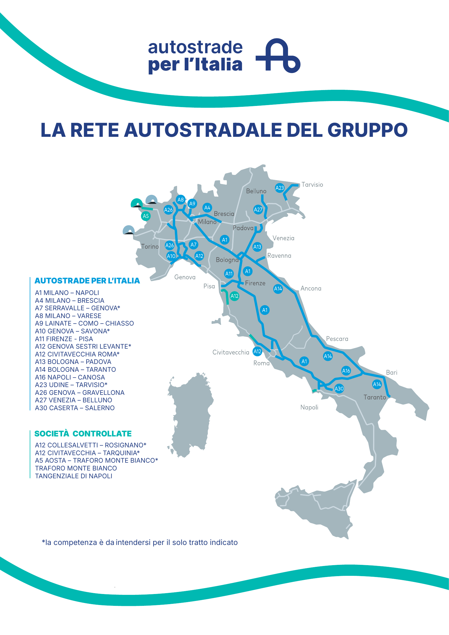
How to read the map
- Blue - Autostrade per l’Italia: sections managed directly by ASPI.
- Turquoise - “Società controllate”: sections and facilities managed by subsidiary companies in the group.
- Asterisk (*): management applies only to the section explicitly named. For example, the map identifies Serravalle-Genova on A7, not the whole of A7.
The map shows the ASPI group's network.
Each concessionaire sets its own rates, including companies within the same group.
For example, the A4 section shown is Milano-Brescia.
How is the final toll calculated?
- Identify the class of your vehicle or combination.
- Split the route by operator and the applicable flatland or mountain tariff.
- Multiply each section's chargeable kilometres by its unit rate.
- Add the amounts and apply the rounding rule.
Why are mountain sections more expensive?
Mountain sections have higher rates because of the costs of tunnels, viaducts and maintenance.
Routes crossing several concessionaires' networks
For a route crossing several networks, calculate the toll using each operator's kilometres and unit rates before rounding the total.
The chargeable distance may include junction links and approaches to toll stations.
How is the amount rounded?
Usually to the nearest 0.10 €: a remainder below 0.05 € rounds down, and 0.05 € or more rounds up. For example, 1.13 € becomes 1.10 €, while 1.16 € becomes 1.20 €. For Tangenziale di Napoli, the operator specifies a 0.05 € increment.
Calculation method: The operator's official explanation.
WORKED EXAMPLE
Class A: 100 km of flatland + 50 km of mountain sections
Assume a hypothetical route entirely on the Autostrade per l’Italia network with exactly these chargeable distances:
| Part of route | Calculation | Amount |
|---|---|---|
| Flatland | 100 × 0.07869 | 7.86900 € |
| Mountain | 50 × 0.09315 | 4.65750 € |
| Before rounding | 7.86900 + 4.65750 | 12.52650 € |
| After rounding | To 0.10 € | 12.50 € |
This example uses a hypothetical route. The total is rounded after adding the charges for each section.
Payment: closed and open systems
Closed system - ticket at entry
Take a ticket when entering and present it at the exit. The toll depends on the recorded route and vehicle class. If using a compatible electronic service, use the lanes marked for that service.
Open system - fixed section charge
Sections with a fixed charge are paid at one toll station, without taking an entry ticket.
Lanes approaching the barriers are marked for cash, card or electronic device payment.
Toll systems and payment methods: Autostrade per l’Italia.